Check out our first day climbing Mt. Whitney here.
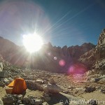
We wake up at 2am (not a typo, unfortunately) and spend an hour getting ready for the day’s hike. I should explain what this entails, as Mt. Whitney is not your average hiking experience. First, all food and items with any scent — including deodorant, tooth paste, etc. — must be kept in a bear canister. (For the record, these plastic round tubs are not only bear-proof, as I had a heck of a time opening them with my opposable thumbs.) The canister must then be kept a distance from the tent. So our belongings are a bit scattered and it takes awhile to prep our day bags and force down a protein bar for breakfast. Another part of the Mt. Whitney experience is the joy of using the bathroom… they do not allow human waste in this area and there certainly aren’t any port-o-potties, so you have to pack out solid waste in a WAG bag. Yup. Not much more to say about that.
We are allowed leave our tents and backpacks behind at Trail Camp, which makes it remarkably easier to hike to the summit. We carry light day packs with essentials like water, food, and cameras. It’s only 5 miles and a gain of 3,500 feet in elevation to the top, but it will be the hardest part of the trail. Once we hit the summit it’s five miles back to camp, and then six miles back to the Whitney portal. In total we are hiking SIXTEEN miles today, which is almost triple the distance we hiked yesterday.
Around 3am we start trekking up the 99 switchbacks. Luckily it’s completely dark at this point and we cannot see the steep drop-offs on the side of the trail. We’re all wearing headlamps and focusing on the path directly in front of us, taking it one step at a time. At around 5:30 the sun begins to rise in a bold line at the horizon:

And we’ve reached Trail Crest at 13,600 feet elevation! At this point I’m thinking we have to be at least half-way there. I consult the map and think, “Piece of cake! We got this!” But the next 2.5 miles are rough.

The valley below glows in early sunlight, providing a nice distraction as we stop and catch our breath every 100 yards or so.


This next image is my favorite from the whole trip. It’s a view out of the “Whitney Windows,” openings between the jagged peaks on the trail.


See the highest peak on the left? That’s where we are headed; there’s still a mile and a half to go. I avoid glancing up because it feels so far away and my feet are starting to slow down.

But I make it!! With a final push to the top we arrive at the Summit Hut and add our names to the register.

I add an exclamation mark after my entry, as I am still shocked I made it to the top. Remember that book I packed to pass the time in case I was too tired / out of shape to go on? I’m happy to report I did not need the book.

We huddle inside the cabin for warmth (it’s incredibly windy up there) and then take some fun photos.


At this moment, I am the tallest point in the 48 contiguous United States!

After attempting more jumping photos, we turn around and begin the five mile return route back to our campsite.


Check out the 99 switchbacks we climbed in the dark at 3am.

This is the scariest part of the trail because it’s partially covered in ice. The hand rails make it easier but we are extra careful with our footing.

We reach Trail Camp and allow ourselves a few minutes to rest and eat more protein bars, then pack up and hit the road. The Whitney portal (where our car is parked) is still six miles away, so we have our work cut out for us. It’s the same trail that we ascended yesterday and we don’t stop for photos. But the downhills are tough on our knees so we take it easy and cling to our walking sticks (which are a godsend). It takes us nearly FIVE hours to hike six miles downhill, much longer than we anticipate. We get to the car, dispose our WAG bags into the proper receptacle (EWW), and drive to Lone Pine for the most deserved pizza I’ve ever tasted. We eagerly gulp down our recovery food and then hit the road for the 3.5 hour drive back to Los Angeles. We are exhausted but proud.
The only physical activity I can compare climbing Mt. Whitney to is running a marathon. I ran three back in 2007 and my muscle memory is sharp: by mile 26 my quads, calves, and glutes were on fire and for the next few days I felt like my body had been run over by a truck. After returning from Mt. Whitney, I felt the burn for about three days, and by day five I was completely back to normal. Not a bad price to pay for such a rewarding trip.
I had one funny realization once I got back to Los Angeles: my longtime desktop photo is a shot of Mt. Whitney. What are the odds?! I picked it from the pre-loaded desktop photos because I found the black-and-white image striking. Little did I know that someday I would summit those peaks! Now I’d recognize that mountain anywhere. Here’s a side-by-side comparison of my desktop photo and an image I snapped on our drive to the Whitney portal.

I leave you with the video footage I shot on my GoPro camera. It was a joy to edit and I’m transported back to this place every time I watch the final cut. Enjoy!


Thanks for this thorough report and the sweet video! A bunch of us, primarily women in our 40s to me, a 60 year old, entered the Whitney lottery for this summer. Your blog post is motivating! Well done to you!
Thank you for the kind comment, Grace! And good luck with the Mt. Whitney permit lottery — it’s an incredible hike and I hope you get to do it. Good on your whole group for seeking out this adventure!